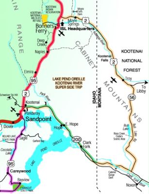
 Travel Distance: 112 Miles / 180 Km
Hope, Clark Fork, Moyie Springs, ID; Troy, MT
Just north of Sandpoint Idaho stay on Idaho 200 east to Hope. The first 33- miles of this 112-mile Super Side Trip is also the beginning of the “Pend Oreille National Scenic Byway.â€
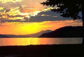
The route allows for stunning vistas along the south shore of Lake Pend Oreille. Watch for wayside exhibits with wide pullouts along this photographic stretch.
Look for the Historical marker at the Hope Peninsula turnoff and take a moment to view the site of Idaho’s first structure “Kullyspell House,†a trading post established by David Thompson in 1809. Sam Owen State Park is one mile past Hope on the Hope Peninsula and Game Preserve. Heading east this route travels by the Denton Slough Waterfowl Area. Watch for a pullout with interpretive panel here. This area is a good place to spot songbirds, eagles, osprey and heron.
Have lunch in Clark Fork or pack a picnic then take a short side trip to Johnson Point Vista. Turn right on Stevens Street, cross the river and turn right. Drive 3 miles to Johnson Creek Road 278, and drive 4 miles to Johnson Point Vista Road. Turn right and drive another mile to the Vista. The gravel road is suitable for passenger cars, and the view at the end of the drive is spectacular. The elevation here is similar to the height of glaciers forming an ice dam for Glacial Lake Missoula 15,000 years ago.
Just east of Clark Fork, across the Montana State Line, there are scenic overlooks at Cabinet Gorge Dam and Noxon Rapids Dam. These sites provide scenic vistas overlooking their spillways. Complete with local interpretive information, beaches and lawn, these are pleasant stops from which to view the Clark Fork River. Adjacent to the Cabinet Gorge Reservoir on Hwy 200 is the small 3-unit Big Eddy Campground open year-round. Just a scant half-mile east of the Hwy 200/56 junction is the Bull River Campground, open Apr. 15 through Sept. 10. Reservable sites through Reserve USA. Dorr Skeels Campground, a 3-unit no-fee year-round site, is located adjacent to Bull Lake in a beautiful mountain setting approximately 2 miles from the Cabinet Mountains Wilderness boundary.
 Turn north onto Highway 56 or Bull Lake Road. One point of great interest is the ancient grove of the Ross Creek Cedars with an interpretive trail through numerous stands of 500-year old trees. Easy access and gentle terrain make this a pleasant stroll for people of all ages. There is a nice 17 unit Forest Service campground called Bad Medicine Campground on Bull Lake nearby.
At the Highway 56/2 junction, turn west to Troy where the road follows along the south shore of the Kootenai River. This historic waterway, used first by the Kootenai Tribe and later by the first white explorer David Thompson on his search for a waterway to the Pacific. Just west of Troy is the Kootenai National Forest Ranger Station with a nice wildlife display and learn more about the hunting, fishing, hiking and camping opportunities that abound in this sparsely populated area.
Watch for the scenic overlook of the Moyie River Canyon, eight miles east of Bonners Ferry, just before crossing the Moyie River Bridge. There are good views of the Moyie Dam, Kootenai River and the Selkirk Mountains here. Approximately 7-miles west of Troy is the Yaak River Campground. This site is immediately adjacent to US Highway 2 and is located at the confluence of the Kootenai and Yaak rivers. A natural forest atmosphere encompasses the campground which is divided by the beautiful Yaak River. Sites can be reserved at Reserve USA. About a mile west of the Yaak River Campground, Turn north onto the Yaak River Road to view Yaak Falls which is .3 of a mile from the Yaak Falls Campground. These scenic falls cascade in a beautiful narrow mountain valley, a photographer’s delight. The sparsely populated Yaak area is rich in history and offers many recreational opportunities away from the crowds. A scenic turnout allows easy viewing of the falls.
Drive time: Allow 3 hours.
 International Selkirk Loop