


Salmo Mountain, at 2,081 m/6,828 ft, is part of the Salmo-Priest Wilderness, an unspoiled wildland. Consult with the Sullivan Lake Ranger Station located at the north end of Sullivan Lake (east of Ione, Wash.) ahead of time to determine the condition of this primitive road and remote location. 509-446-7500
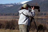
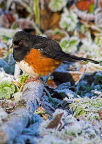
Birds to see: Clark’s Nutcracker, Boreal Owl, Boreal and Chestnut-backed Chickadees, White-winged Crossbill Viewing: Hiking trail at trailhead. Scenic viewpoint about 2 miles west on Forest Road 270 from its junction with Forest Road 2220.
Driving Directions: From Metaline Falls, drive north about 1.6 km/1 mi on State Highway 31 to the Sullivan Lake Road (County Road 9345). Turn right on the Sullivan Lake Road, drive east for about 7.2 km/4.5 mi to the Sullivan Creek Road (Forest Road 2200). Turn left on FR 2200, drive east for about 8 km/5 mi to FR 2220. Continue on FR 2220 for about 16 km/10 mi to trailhead at the end of the road.
GPS: 48° 57’ 26” N 117° 04’ 40” W

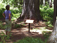
Forest Service historical interpretation site and trailhead near the Sullivan Lake Ranger Station. Mill Pond is a small lake surrounded by a mixed conifer forest. Birds to see: Warblers, Spotted Towhee, hummingbirds, bluebirds, woodpeckers, waterfowl Viewing: After leaving the parking area, the trail immediately crosses a bridge over the outlet of the mill pond with spectacular views of the deep river gorge from the bridge. The trail then follows the lakeshore for a short distance before beginning the loop. Go clockwise around the loop for the best views. Interpretive signs explain the history of the area. Driving Directions: From Metaline Falls, Wash., drive north about 1.6 km/1 mi on State Highway 31 to the Sullivan Lake Road (County Road 9345). Turn right on the Sullivan Lake Road, drive east for about 5.6 km/3.5 mi to the Mill Pond Interpretive Site on right side of road. Mill Pond Campground at south end of Mill Pond. GPS: 48° 51’ 33” N 117° 17’ 59” W
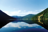
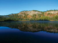
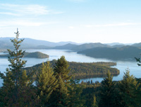
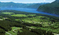
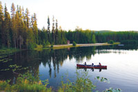
This lake is a popular recreation spot nestled in the mountains. A 6.5 km/4 mi lakeshore National Recreation Trail is found on the east side of the lake. On the north end, there is a 1 km/0.6 mi interpretive nature trail. Noisy Creek Trail climbs 884 m/2,900 ft to Hall Mountain, with spectacular views of the lake, mountains and wildlife.
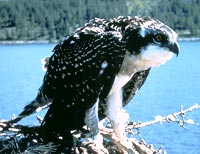
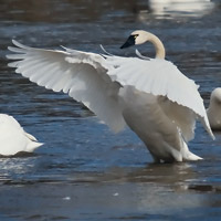
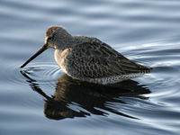
Birds to see: Bald Eagle, Osprey, Common Loon, warblers, swans, grebes, dippers and various waterfowl.
Viewing: Drive south along the lakeshore, stopping at the south end of the lake at Noisy Creek Campground.
Driving Directions: From Metaline Falls, Wash., go north 1.6 km/1 mi on State Highway 31, and turn right onto Sullivan Lake Road (County Road 9345). Proceed approximately 9.5 km/6 mi to the north end of the lake.
GPS: 48° 50’ 22.78” N 117° 17’ 1.31” W
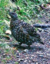
Harvey Creek is a fast-flowing stream originating in Bunchgrass Meadows (48 ha/120 ac). A high-elevation, wet meadow, it is surrounded by forest dominated by subalpine fir, Engelmann spruce and occasional whitebark pine. Consult with the Sullivan Lake Ranger Station to determine the condition of this primitive road and remote location. 509-446-7500
Birds to see: Spruce and Dusky Grouse; Dipper; White-winged and Red Crossbills; Black-capped, Mountain, Chestnut-backed and Boreal Chickadees; warblers.
Viewing: Hike through the meadow and surrounding forest. View the vista from the top of Monumental Mountain.
Driving Directions: From Ione, Wash., go south on State Highway 31 about
1.2 km/0.75 mi, then cross the Pend Oreille River on the Sullivan Lake Road (County Road 9345). Drive about 11 km/7 mi northeast on the Sullivan Lake Road to the Harvey Creek Road (FR 1935). Drive southeast on the Harvey Creek Road for about 14.5 km/9 mi to Bunchgrass Meadows on the left. Monumental Mountain is another 3.2 km/2 mi south.
GPS: 48° 41’ 12” N 117° 10’ 18” W
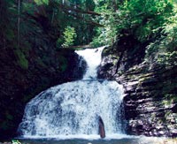
At a Washington Department of Transportation rest stop with paved parking lot and restrooms, there is a short hiking trail that follows Sweet Creek to a waterfall. Located near the Pend Oreille River in a mixed conifer forest.
Birds to see: Vireos, warblers, woodpeckers
Viewing: The trail makes a loop on some low ridges above the river, and the boardwalk section offers terrific views.
Driving Directions: From Ione, Wash., proceed 9 km/5.5 mi north on State Highway 20, and pull into rest stop on the left.
GPS: 48° 49’ 24.52” N 117° 23’ 49.39” W
This 29 ha/72 ac lake and its surrounding area boast a variety of birdlife and is an important nesting area. Also a good place to see moose.
Birds to see: Goldeneye, snipe, grebes, warblers, woodpeckers, flycatchers
Viewing: The first 0.8 mile of this 1.5-mile trail is wheelchair accessible. The trail has an overlook of Big Meadow Lake in a high, dry, ponderosa pine valley. Start the loop past wetland to a wildlife viewing area. Meadow Creek Trail links to a 0.8-mile side trail to a replica of a homestead cabin and to the Lake Shore Trail No. 120, a scenic easy 1.5-mile loop around Big Meadow Lake. Wildflowers and lots of viewing of migratory birds in the spring.
Driving Directions: From Ione, Wash., turn west off State Highway 31 onto Houghton Street and drive 0.4 mile to Greenhouse Road. Turn left on Greenhouse and drive 0.1 mile, turn right on the Smackout Pass Road (County Road 2714) west about 4 km/2.5 mi to the Big Meadow Lake Road (County Road 2695). Turn left on the Big Meadow Lake Road, drive west about 8 km/5 mi to Big Meadow Lake Recreation Area.
GPS: 48° 43’ 34” N 117° 33’ 39” W
Tiger Meadows is a large (55 ha/135 ac) moist meadow without developed facilities. Nile Lake is relatively shallow, about 8 ha/20 ac with a primitive boat ramp. Frater Lake (5 ha/12 ac) is a developed recreation site with ample parking, restrooms and picnic facilities.
Birds to see: Sandhill Crane (rarely), swallows, Bluebirds, Common Snipe, Sora, warblers, waterfowl, woodpeckers
Driving Directions: From Tiger, take State Highway 20 west about 6.5 km/4 mi to Tiger Meadows on left. Proceed 0.8 km/0.5 mi west to Nile Lake on left. Proceed 0.4 km/0.25 mi to Frater Lake on right.
GPS: 48° 39’ 17” N 117° 29’ 01” W
This forested refuge (16,831 ha/41,573 ac) contains several creeks and small lakes. The refuge provides important habitat for many mammals and more than 200 bird species.
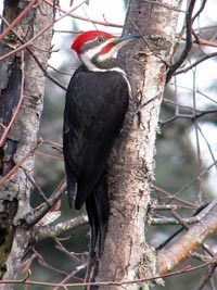
Birds to see: Bald Eagle; Northern Goshawk; White-headed, Pileated and Black-backed Woodpeckers; warblers, Nuthatches, Thrushes, Flycatchers, Vireos, waterfowl
Viewing: Open roads, hiking trail, interpretive trail; check in at park headquarters for a list of five birding hot spots on the refuge.
Driving Directions: Located 20 km/13 mi southeast of Colville, Wash., off Highway 20. Watch for the refuge sign just after passing White Mud Lake; at the junction make a right turn onto Artman-Gibson Road. The sign states the refuge is 7 miles away. Travel 1.7 miles until reaching a four-way intersection. Turn left onto Kitt-Narcisse Road and follow it for 2.2 miles where the road forks. Take the right fork onto Bear Creek Road (a dirt road), and follow it for 3.3 miles. From Newport, Wash., follow Highway 20N to Tiger, Wash., and continue on Highway 20 (west) to where it intersects with Artman-Gibson Road (about 30 miles), turn left onto Artman-Gibson Road. The refuge headquarters is a brown log building.
GPS: 48° 27’ 42” N 117° 43’ 51” W
Here you’ll find a riparian black cottonwood gallery, floodplain meadows, wetlands, open water, river frontage and upland mixed conifer forest.
Birds to see: Western Tanager, Osprey, Bald Eagle, Great Blue Heron, warblers, Virginia Rail, Sora, Common Snipe, Red-winged and Yellow-headed Blackbirds, hawks, owls, grouse, swan, Violet Green Swallow, Thrushes, Song Sparrows, Yellow Chat, Marsh Wren, Bobolinks, waterfowl, Vireos, Savannah Sparrows
Viewing: Parking near green hatchery building. Open to foot traffic only from parking area. Wetland areas closed to any traffic during waterfowl nesting season (April 15 to July 15). Viewing from trails and vantage points OK year-round.
Driving Directions: From Usk, Wash., cross the bridge and drive about 11 miles north on the east side of the Pend Oreille River off of LeClerc Road.
GPS: 48° 26’ 22.54” N 117° 16’ 39.07” W

This riparian woodland and moist meadow is on the Pend Oreille River floodplain.
Birds to see: Western Tanager, Osprey, Bald Eagle, warblers, Virginia Rail, Common Snipe, Red-winged and Yellow-headed Blackbirds, Bobolinks, waterfowl, Vireos, Savannah Sparrows
Viewing: Parking area off the highway. Primitive trail on east side of the highway. Little Pend Oreille National Wildlife Refuge meadow on the west side of the highway is open to foot traffic.
Driving Directions: From Cusick, Wash., go north on State Highway 20 about 6 km/3.8 mi to junction of Westside Calispell Road. Parking area is east of the highway.
GPS: 48° 23’ 17” N 117° 18’ 38” W
This nature education site is developed on the shore of the Pend Oreille River by the village of Cusick.
Birds to see: Geese, Osprey, ducks, Cormorants, sparrows, hummingbirds
Viewing: Shoreline interpretive trail
Driving Directions: At Cusick, Wash., turn east off State Highway 20 onto Monumental Street. Proceed about 0.8 km/0.5 mi to river’s edge.
GPS: 48° 20’ 12.91” N 117° 17’ 37.75” W
This privately owned wetland and lake is viewable only from a public road.
Birds to see: Swans including Tundra Swans in March, migrant shorebirds, several species of waterfowl, raptors
Viewing: Viewable only by driving along Westside Calispell Road.
Driving Directions: From Newport, Wash., go north on State Highway 20 about 19 km/12 mi to Westside Calispell Road, turn west (left) and follow this 9.6 km/6 mi loop back to Highway 20.
GPS: 48° 16’ 42” N 117° 21’ 54” W

This Forest Service campground is adjacent to the Pend Oreille River in a mixed conifer forest.
Birds to see: Bald Eagle, Osprey, waterfowl, warblers
Viewing: Inside park boundaries access an interpretive trail along the Pend Oreille River with opportunities to view Osprey and Golden and Bald Eagles. This is an archaeological interpretive trail that has 12 displays about the Kalispel Tribe. The 12 interpretive displays consist of written text, picture and drawings, and an elevated boardwalk overlooking the inside of a camas oven where the Kalispels once baked camas root. You will also have access to many beautiful views of the Pend Oreille River from various points along the trail.
Driving Directions: From Newport, Wash., drive east across Pend Oreille River on State Highway 2. On the east shore of the river, make an immediate left turn onto LeClerc Road (County Road 9325). Drive north for about 2 miles to campground on left hand side of road at 1061 LeClerc Rd. South.
GPS: 48° 12’ 47” N 117° 03’ 07” W
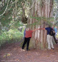
This grove of western red cedar and western white pine trees between 200 and 800 years old provides habitat for birds that require old-growth forests. A relic grove of trees, this 605 ha/16 ac site escaped fires in the past.
Birds to see: Thrush, Winter Wren, Cassin’s Vireo, Pileated Woodpecker, Ruffed Grouse, Northern Goshawk
Viewing: Walk the short interpretive trail while keeping your eyes and ears alert to a variety of forest species.
Driving Directions: From Priest River, Idaho, take Highway 57 north for about 30 miles; turn left (west) at the Priest Lake Ranger District headquarters onto Forest Road 313 near milepost 32; drive about 1.5 miles to the trailhead.
GPS: 48° 34’ 12.32” N 116° 58’ 26.70” W
Upper Priest Lake contains one of the largest contiguous blocks of old-growth red cedar in the continental United States. Several species nest at this site. Upland habitats surrounding the lake and the Thorofare contain a number of high-interest nesting species.
Birds to see: At the Visitor Info Center and Dickensheet, look for Spruce and Blue Grouse, American Three-toed and Black-backed Woodpeckers, Clark’s Nutcracker, Swainson’s Thrush, Hermit and Varied Thrushes, Chickadees, and Nuthatches. At Upper Priest Lake, several species nest including Bald Eagle, Barrow’s Goldeneye, Harlequin Duck and Willow Flycatcher. Common Loon have been noted at this site during breeding season. Upland habitats surrounding the lake and the Thorofare contain a number of high-interest nesting species, such as Cassin’s Vireo, Townsend’s and MacGillivray’s Warblers, and Northern Goshawk.
Viewing: There are two main areas of interest. From the Visitor Info Center, there is a nice hiking trail behind the parking area going into mixed conifer habitat. The area around the Dickensheet Campground offers access to further bird-viewing opportunities. The second area requires a hike from Lion’s Head Campground to Upper Priest Lake, a roadless wilderness. Can be accessed by boat, canoe or kayak via the Thorofare between Priest Lake and Upper Priest Lake.
Driving Directions: Visitor Info Center – From Priest River, Idaho, take Highway 57 north for 22.3 miles to find the info center on the right (east) side of the highway. Dickensheet Campground: From the visitor center, go 0.7 mile north to Coolin Road; then right (east) onto Coolin Road; go 1 mile to campground. Upper Priest Lake – From Dickensheet, go east to Coolin staying on East Shore Road; go north to Lion’s Head Campground and trailheads.
Visitor Info GPS: 48° 26’ 55.21” N 116° 54’ 52.64” W
Lion’s Head Campground GPS: 48° 44’ 40.56” N 116° 49’ 57.38” W
Upper Priest Lake GPS: 48° 45’ 55.86” N 116° 51’ 53.63” W

Situated (163 ha/402 ac) along the Pend Oreille River consisting of 50 percent riverine riparian habitat and 30 percent low-elevation mixed conifer habitat. This site is important to breeding and brood-rearing waterfowl but is particularly important to migrating diving ducks. Total waterfowl numbers can exceed 2,000 individuals. Shorebirds can be found here, as well as nesting Bald Eagle.
Birds to see: Redhead, Lesser Scaup, Common Goldeneye, Ring-necked Duck, Bufflehead, Common Merganser, American Wigeon, Mallard, Crested Cormorants, Teals, Coots, Great Blue Herons, Bald Eagles, Osprey. Up to 25 Double-crested Cormorants, which are rare in the area, appear in late fall.
Driving Directions: From Sandpoint, Idaho, take U.S. Highway 95 south and turn right (west) onto Lakeshore Drive; travel 10.2 miles to Morton Slough. Lake access is available at WaterLife Discovery Center (1.7 miles from the highway) or at Springy Point Campground (3 miles from the highway).
GPS: 48° 11’ 52.15” N 116° 41’ 49.38” W

Found on Lake Pend Oreille amidst woodland, the WaterLife Discovery Center is a nature center still being developed at the Idaho Fish and Game’s Sandpoint Hatchery. The center includes a small pond with underwater viewing windows and views of Lake Pend Oreille. Located on the shore, it overlooks an important wintering area for several species of waterfowl including Redheads, Canvasbacks, Scaup and Ringnecks.
Birds to see: Waterfowl, Bald Eagles, Ospreys, Great-horned Owl, Cormorants, Pileated Woodpeckers, a wide variety of woodland and riparian neotropical migrant and year-round song birds, hummingbirds.
Viewing: Along the shore on the Discovery Center grounds. A woodland setting is across Lakeshore Drive where there is an interpretive nature trail.
Driving Directions: From Sandpoint, Idaho, take U.S. Highway 95 south and turn right (west) on Lakeshore Drive. Drive approximately 1.7 miles to the center. Park is on the north side of the road.
GPS: 48° 14’ 18.78” N 116° 33’ 6.22” W
This 58-acre glacially created, pothole lake is encircled by coniferous forest.
Birds to see: Osprey, Great Blue Heron, Northern Flicker, Steller’s Jay, Mountain Bluebird, Cedar Waxwing and Western Tanager. Ducks and geese use the lake until late winter.
Viewing: A foot trail around the lake and along Cocolalla Creek takes you under canopies of a wide variety of Idaho’s trees.
Driving Directions: From Sandpoint, Idaho, take U.S. Highway 95 south for 8 miles and turn right (west) on Dufort Road at milepost 468.5; go 1.6 miles to winter entrance or 1.8 miles to summer entrance.
GPS: 48° 9’ 50.76” N 116° 38’ 14.86” W
At 4,000 acres this park is Idaho’s largest park consisting of low-elevation mixed conifer and ponderosa pine habitat along the shore of Lake Pend Oreille.
Birds to see: Ruffed Grouse, Swainson’s Thrush, Townsend’s and MacGillivray’s Warblers, Red-breasted Nuthatch, Cassin’s Vireo, Cordilleran Flycatcher, Mountain Bluebird, Northern Pygmy-Owl, Rough-legged Hawk, Red-necked Grebe, and Barrow’s Goldeneye
Viewing: The full-service park has an interpretive center, camping facilities, camping cabins and more than 40 miles of hiking trails offering excellent opportunities for spotting numerous bird species.
Driving Directions: From Coeur d’Alene, Idaho, take U.S. Highway 95 north for about 20 miles; at Athol (milepost 449.1), turn right (east) onto State Highway 54. Travel 4 miles to park entrance.
GPS: 47° 58’ 13.87” N 116° 33’ 59.85” W
The loop is a 10-mile paved/gravel road that is 80 percent riverine riparian habitat. This site supports more than 2,000 ducks and Canada Geese during migration in the spring and fall. Significant populations of waterfowl, secretive marsh birds and shorebirds nest here.
Birds to see: American Wigeon; Mallard; Green-winged teal; Lesser scaup; Common Goldeneye; Bufflehead; Canada Goose; Killdeer; Wilson’s Snipe; Greater Yellowlegs; Long-billed Dowitcher; Western, Spotted and Solitary Sandpipers; Veery; Swainson’s Thrush; Vaux’s Swift; Bald Eagles
Viewing: The first part of the drive is the Oden Bay area, mostly residential. Proceeding on, the entire area is a rich bird area with opportunities to pull off the road and observe the marshlands bordering the roadway.
Driving Directions: From Sandpoint, Idaho, follow U.S. Highway 95 north for about 1.5 miles to State Highway 200; continue east. At milepost 35, turn right at the Sportsman’s Access and go under bridge. Turn left on Sunnyside Road. Go 9.5 miles to Hawkins Point; follow Sunnyside Road east to return to Highway 200. Highway 200 from Sandpoint to the Montana state line is a National Scenic Byway known for its sweeping vistas of Lake Pend Oreille and the geography it follows. The byway offers exceptional birding opportunities all along its route.
GPS: 48° 19’ 3.32” N 116° 27’ 27.93W (junction of Hwy. 200 and Sunnyside Road)
The habitat is generally shoreline, marshes and drift yards as State Highway 200 follows the northern shoreline of Lake Pend Oreille. The Hope Subloop is a 10- to 15-mile auto route.
Birds to see: Hope provides good viewing opportunities for Common Loon in October, as well as for many grebe species. Denton Slough is a Western Grebe nesting area (30-plus nests) with courtship displays in June. Summer waterbirds also include Double-crested Cormorant, Great Blue Heron, Canada Goose and Black Tern. Thousands of waterfowl (American Wigeon, Redhead, Lesser Scaup, Green-winged Teal, Mallard, Tundra Swan, Canada Goose) use Denton Slough during migration. At Johnson Creek, swallows, warblers, flycatchers, Eastern Kingbird, Bald Eagle and Common Merganser can be seen in the spring and summer.
Viewing: Hope Peninsula, follow signs to Sam Owen Campground where there is good shore access and a nice hiking trail through mixed conifer forests opposite the entryway to the park. Back on Highway 200 east bound, watch for Sportsman’s Access signs for Denton Slough. In downtown Clark Fork, turn right at the Sportsman’s Access sign and follow to Johnson Creek. Large gravel parking area with some short hiking trails that offer good habitat viewing along the Clark Fork River as it drains into Lake Pend Oreille.
Driving Directions: From Sandpoint, Idaho, follow U.S. Highway 95 north for about 1.5 miles to State Highway 200 and head east toward Hope; many pull-outs for viewing. Pass Hope and East Hope and turn right (west) on Peninsula Road to Sam Owen Campground. Continue east on Highway 200 to view Denton Slough and the drift yard; then on to Clark Fork, where you turn right to Johnson Creek Sportsman’s Access 4 miles away. Sam Owen Entrance GPS: 48° 13’ 13.48” N 116° 16’ 56.91” W
Denton Slough drift yard road entrance GPS: 48° 10’ 49.06” N 116° 14’ 1.27” W
Johnson Creek GPS: 48° 8’ 20.31” N 116° 13’ 42.06” W
Consisting of 500-year-old giant red cedars in a rain forest atmosphere. You’ll pass Bad Medicine Campground on 7-mile-long Bull Lake with habitat consisting of open water and various types of flora and dense conifers. The waters of Ross Creek come from the rugged alpine basins and peaks of the upper Ross Creek Valley, from which centuries of erosion and glaciation have deposited the soils of the cedar grove. The cathedral atmosphere of the grove is magnified by the knowledge that many of these trees were growing before Columbus set sail for the new world.
Birds to see: Some of the more regularly occurring species include Pileated, Hairy and Downy Woodpeckers; Belted Kingfisher; Bohemian and Cedar Waxwings; Pygmy and Great Horned Owls; Common Loon; many duck species; grouse; jays; hummingbirds; bluebirds; and chickadees. Bald Eagles, Osprey and Harlequin Ducks can be seen seasonally.
Viewing: Ross Creek Cedars is a 100-acre scenic area with a mile-long paved nature trail with informational signs and benches along the route, full of wonders big and small, and it is a very easy walk over mostly flat terrain.
Driving Directions: Located on the extreme western edge of Montana. From Bonners Ferry, Idaho, follow U.S. Highway 2 east 5 km / 2 mi east of Troy, Mont., and turn south onto Highway 56; drive 29.6 km / 18.2 mi to a well-signed turnoff to Bull Lake and the Ross Creek Cedars. From Sandpoint, Idaho, follow State Highway 200 for 32 km / 20 mi east of Clark Fork to Highway 56, turn north (left) and go 26.8 km / 16.8 mi to the turnoff left at the south end of Bull Lake. Follow signs leading 4 miles west, up a paved road to the Ross Creek trailhead. Stop at the scenic turnout about 2 miles up the road for a scenic view of the Cabinet Mountains and Bull River valley. You’ll be able to hear Ross Creek Falls from this point.
Ross Creek Cedars GPS: 48° 12’ 31.91” N 115° 54’ 49.69” W
Covering an area of 488 ha/1,207 ac, the lake is popular for fishing and wildlife viewing. The habitat consists of open water, marshland, grass and shrubland, and lowland forest. If you love ducks, this is the place, with 13 species known to breed here and up to 6,000 migratory ducks visiting each spring and fall.
Birds to see: Migratory ducks; American Coot; Ruffed Grouse; Common Snipe; Wild Turkey; American Wigeon; Mallard; Green-winged Teal; Lesser Scaup; Morning Dove; Common Goldeneye; Bufflehead; Canada Goose; American White Pelican; Killdeer; Wilson’s Snipe; Greater Yellowlegs; Long-billed Dowitcher; Western, Spotted and Solitary Sandpipers; Veery; Swainson’s Thrush; Vaux’s Swift; Bald Eagles
Viewing: From the first parking area, go left on McArthur Lake Road and stay right at the “Y.” Follow White Mountain Road to the south fork of Dodge Creek where there is a second parking area with a trail through the marshland. Remember to watch for nesting area closure signs. There is a blind located behind the Management Area Office located on Highway 95 just south of the Sportsman’s Access Road.
Driving Directions: From Bonners Ferry, Idaho, travel south on U.S. Highway 95 for 13 miles. From Sandpoint, Idaho, travel north on U.S. Highway 95 for 18 miles. Just north of McArthur Lake Dam turn west on McArthur Lake Road at the Sportsman’s Access sign; take the first left (south) to get to the parking area, restroom and boat launch.
GPS: 48° 31’ 15.08” N 116° 26’ 30.38” W

This refuge (1,123 ha/2,774 ac) provides diverse habitats for a large variety of wildlife including moose, deer, elk, bear and otter. Established in 1965 as a migratory waterfowl refuge, Kootenai National Wildlife Refuge provides habitat to more than 220 bird, 45 mammal and 22 fish species.
Birds to see: Bald Eagle; American Wigeon; Northern Pintail; Green-winged and Cinnamon Teal; Mallards; Tundra Swan; Canada Goose; Wood Duck; Goldeneye; Northern Shoveler; Gadwall; Ring-necked Duck; Black Tern; Grebes; Rough-legged Hawk
Viewing: Blinds; Myrtle Creek Trail, Chickadee Trail and three other hiking trails; ADA spotting scopes; 7.2 km/4.5 mi auto tour route with pullouts
Driving Directions: Located just 8 km/5 mi west of Bonners Ferry, Idaho. Take the exit on the south side of the bridge in downtown Bonners Ferry; stay on Riverside Road along the Kootenai River across the Kootenai Valley to the Westside Road. Turn right and proceed 0.5 mile to the Visitor Information Center.
GPS: 48° 42’ 25.11” N 116° 24’ 54.73” W

This conservancy (931 ha/2,600 ac) features more than 220 bird species and is an important migration corridor for wildlife in the Selkirk and Cabinet/Yaak ecosystems. The ranch includes four miles of Kootenai River shoreline and two tributaries to the river, Ball Creek and Trout Creek.
Birds to see: The northwest corner is flooded during the spring and attracts waterfowl including Tundra Swan and three species of teal. Lewis’s Woodpecker can be seen in the spring. American Kestrel and Great Horned Owl nest in the area. American Dipper is a regular in Ball and Trout creeks near bridges. Long-billed Curlew are in the fields May/June.
Viewing: 500 acres of public access are located in the northwest section of the property. North of the farmhouse that is on the left, a walk-in access trail leads to the dike on the right (east) side of the road.
Driving Directions: From U.S. Highway 95 in Bonners Ferry, turn west onto Riverside Road on the south side of the bridge over Kootenai River; go about 7 miles to Westside Rd. Turn right (north) on Westside Road and go about 6 miles to Ball Creek Ranch house on the left; guest parking and public access is beyond the house and on the left.
GPS: 48° 47’ 50.53” N 116° 24’ 45.96” W

This (820 ha/2,026 ac) fish and wildlife habitat comprises floodplain and coniferous forest with unique viewing areas and trails. During April, surface water accumulations support thousands of migrating waterfowl. By late May, Boundary Creek flows peak, filling the floodplain wetlands.
Birds to see: Wild Turkey, Tundra Swan, Canada Goose, White-fronted Goose, Northern Pintail, Mallard, Wood Duck, Red-tailed Hawk, Northern Harrier, Rough-legged Hawk, Great Horned Owl, Great Blue Heron
Viewing: From either picnic area there are hiking trails. Mountain bikes and other nonmotorized travel is easy on foot trails from second picnic area. Wood Duck boxes throughout area. Active Bald Eagle nest. Large game can often be seen such as elk, deer and bear.
Driving Directions: From Bonners Ferry, Idaho, take U.S. Highway 95 north for 21 km / 13 mi to its junction with State Highway 1. Turn left onto Highway 1 and follow it north for 3.2 km / 2 mi to the Sportsman’s Access sign. Turn left (west) on Copeland Road. Follow it across the valley to the Westside Road, and turn right (north) for 10.5 miles on paved road (stay right at all intersections). Watch for one access to a picnic spot, on the right; otherwise, when it turns to gravel at the intersection of Boundary and Smith Creek roads, continue north on Boundary Creek Road to the end.
GPS: 48° 59’ 45.74” N 116° 34’ 2.17” W

A designated Ramsar site (7,000 ha/17,000 ac) on the Pacific Flyway, this endangered wetland complex provides invaluable refuge for thousands of nesting birds and is a critical staging area for countless migrants.
Birds to see: Owls, Yellow Warbler, Black-headed Grosbeak, Eastern Kingbird, Cedar Waxing, raptors, herons, ducks, Long-billed Curlew, Bobolink, Savannah Sparrow, Meadow Lark
Viewing: Viewing blinds along boardwalk and trails near interpretation centre, canoeing access, two viewing towers.
Driving Directions: Located 11 km/7 mi west of Creston, B.C. Interpretation Centre and boardwalks accessed from Highway 3. Turn south on West Creston Road from Highway 3, and the Wildlife Centre is about 1 km from the highway; just look for the big red roof on your left.
GPS: 49° 7’ 9.09” N 116° 37’ 57.41” W
Duck Lake, on the Creston Valley Wildlife Management Area, is a shallow freshwater lake (1,400 ha/3,500 ac) bordered by cattail marshes to the north, south and west, and the Purcell Mountains to the east. Duck Lake sits at an elevation of
531 m/1,744 ft above sea level and can be accessed by car all around; however, there is no connection to the north where the dyke meets Highway 3A. Duck Lake boasts a wide variety of bird species and mammals. Late April through July offers the best viewing.
Birds to see: More than 20 species of ducks, geese and swans; mergansers; herons; Bittern; six species of grebes; Sora; Virginia Rails; Forster’s and Black Terns; American White Pelicans; and a wide variety of shorebirds (in late April and early May).
Viewing: Birds can best be viewed from the dyke south of Duck Lake, at Sirdar (down below the railroad), and at the north end by the pump house. The dyke west of Duck Lake offers limited viewing opportunities when leaves are on the trees.
Driving Directions: From Creston, B.C., follow Highway 3A north to Wynndel. Turn left on Lower Wynndel Road just before the Wynndel Store. Go across the railroad tracks and then turn right on Duck Lake Road. Follow Duck Lake Road to Channel Road, then take a right. Follow Channel Road for approximately 10 km/6 miles or until you reach the dyke at the south end of Duck Lake. To access the pump house to the north, follow the dyke to the west and north until you reach the pump house, but you will have to turn around and backtrack as there is no exit that way. Sirdar can be accessed via Highway 3A at Sirdar. Go past the Sirdar Pub and take an immediate left down over the railroad. There is an unpaved parking area. The lake is a short, 2-minute walk down from the parking lot.
Access: Vehicle, non-motorized boats, hiking, biking
GPS: 49° 12’ 56.23” N 116° 36’ 21.34” W

Lovely vistas across the lake and an extensive network of trails through the park and along the Pilot Peninsula to view local birds. Visit the historic Pilot Bay Lighthouse! This park offers trails, picnic tables, pit toilets and basic tent camping.
Birds to see: Expect to see mixed woodland species; low chance of rarities.
Viewing: There is no viewing platform, but there are several natural viewing areas along the lake. Follow either trail for shoreline viewing. Hike in on two easy trails. One to Sawmill Bay and another to the Pilot Bay Lighthouse. Hike-in wilderness camping and boat-in camping
Driving Directions: Pilot Bay Provincial Park – On Highway 3A, turn south on Pilot Bay Road just before the ferry landing on the east shore at Kootenay Bay. Follow to the end. Crawford Bay Wetlands – Off Highway 3A just south of the community of Crawford Bay opposite Crawford Creek Road, find access to the west side of Crawford Bay via Peters Road to Fishhawk Bay Road. Follow to the end.
Pilot Bay parking area GPS: 49° 38’ 19.76” N 116° 52’ 47.94” W
Crawford Bay Wetlands GPS: 49° 39’ 50.35” N 116° 49’ 47.01” W

This park (257 ha/635 ac) is located along the West Arm shores of Kootenay Lake. The Kokanee Creek delta ecology includes many species of birds, mammals and plants. Multiple trails, interpretive centre, camping, easy parking, picnic and barbecue areas, children’s playground, public boat launch and good beaches with swimming.
Birds to see: Excellent in spring for warblers, woodpeckers, vireos, flycatchers, dipper and other passerines. Raptors, especially owls, are also present. Killdeer are easy to spot in summer. Bonaparte’s Gull and Cormorant are occasional visitors.
Viewing: Most areas allow great viewing opportunities. There are two distinct sections to the park: the lakeside and the lower mountain slopes. Both are well signed and there is a full Visitor Centre in summer. Renowned as main lake spawning area for the iconic, local salmon (in fall) – the kokanee – with great access along the spawning channel.
Driving Directions: From Nelson, B.C., follow Highway 3A north along the west shore of Kootenay Lake. Between the 18 and 19 km markers, see a large, well-signed entrance from the highway.
GPS: 49° 36’ 23.11” N 117° 7’ 16.32” W

Stunning subalpine and true alpine environments are reached by undertaking some of the most rewarding (and strenuous) hiking in the region. Dense, dry coniferous forest gives way to lush, delicate waterlogged summer meadows with jaw-dropping mountain vistas, and a string of serene photogenic mountain lakes. Safe, marked access well above the treeline is possible.
Birds to see: With luck, most if not all of the region’s alpine birds will be available, including rarities such as the Golden Eagle.
Viewing: More birds will be found at lower altitudes but will be harder to see. Fewer species are visible in the higher, open areas, but as these are true alpine survivalists, they may be more rewarding to the serious birder.
Driving Directions: From Nelson, B.C., go north on Highway 3A for 18.5 km. Almost 12 km southwest of Balfour, take the Kokanee Glacier Forestry Service Road which is just past the entrance to Kokanee Creek Provincial Park. Follow signs 16 km to parking at Gibson Lake. Allow one hour for driving the forestry road section. Do NOT attempt without 4WD vehicle in spring or fall.
Access: 4WD vehicle in spring and fall to trailhead, hike into the park.
Trailhead coordinates: GPS: 49° 43’ 52.25” N 117° 9’ 19.99” W

Lakeside Park in Nelson is the pride of Nelson’s waterfront and a key congregation hot spot for waterfowl. The park has a wide promenade, covered picnic area and a paved walking trail. Visit in early spring or late fall when the park is less busy.
Birds to see: Waterfowl including the Western and Red-throated Grebe; Redhead; Hooded Merganser; Barrow’s Goldeneye and the Red Breasted Merganser. Ospreys common in season.
Viewing: Access is easy at any point of Nelson’s waterfront. Follow the paved Centennial Pathway along the shoreline.
Driving Directions: Highway 3A south bound – Cross the Orange Bridge that spans the West Arm of Kootenay Lake, and follow 3A into Nelson, turn right on Poplar Street. From Highway 6 north bound – Follow signs through Nelson to “ferry terminal.” Turn left on Hall Street, go one block and turn right on Lakeside Drive. The park is all along the shoreline.
GPS: 49° 30’ 25” N 117° 16’ 54” W
This wetland habitat (61 ha/151 ac) is located along the Slocan River. The area is a shallow, reed-and-rush-choked waterway home to many waterfowl and wildlife.
Birds to see: Swan, geese, ducks, eagles, osprey
Viewing: Suggest cycling from Slocan City south to Lemon Creek on the Slocan Valley Rail Trail, 10 km/6 mi. This will take you in close proximity to the sanctuary.
Driving Directions: Along the Slocan River between Slocan City and Lemon Creek, B.C., off Highway 6, north of Nelson. Shuttle service is available from Smiling Otter Kayak & Canoe in Slocan City if canoeing.
Access: By canoe only along the Slocan River, flat water about 8 km from Slocan City
GPS: 49° 42’ 6.50” N 117° 28’ 46.73” W
Easy 10 km/6.2 mile drive up into a subalpine area of Whitewater Ski Resort, open year-round. From there intrepid hikers can explore the unmarked ski trails in search of mountain species.
Birds to see: Townsend’s Warbler, Gray Jay, Clark’s Nutcracker, Mountain Chickadee, Alder Flycatcher and Varied Thrush
Viewing: All along the 6.2-mile access road, passing through various habitat changes. Ski trails in winter and hiking trails in summer from the resort. Best strategy is to park safely on the roadside (there are a few pullouts) and wait. Patience required. Hiking at the top in summer is at your own risk: This is wild backcountry.
Driving Directions: From Nelson, B.C., take Highway 6 south toward Salmo for 10 km/6.2 mi. The road is clear year-round, but carry chains or use 4WD in winter.
Access: Always accessible in winter despite altitude. Easy access to subalpine environment but will require hiking.
GPS: 49° 26’ 35.71” N 117° 08’ 44.61” W

A complex riparian ecosystem, this spot is rich in birdlife along the shores of the Columbia River system. Admire the complexities of the seasonal marsh formed here by a backwater channel of the main river. Amphibians (frogs and salamanders), reptiles (turtles and snakes) and birds are highly dependent on this habitat. You can also observe evidence of beaver activity (cut shrubs, entrances to dens). The Waldie Island Trail runs through a wildlife preserve and, because of ecological sensitivity, is meant for pedestrian traffic only. Includes a Great Blue Heron Reserve and a chance to see mammals such as deer and elk.
Birds to see: Hooded Merganser, Double-crested Cormorant, Northern Pintail, Marsh Wren, Yellow Warbler, Ruby-crowned Kinglet
Viewing: 1.5 km/1 mi self-guided interpretive trail accessed by crossing the 30 metre long footbridge. After crossing the bridge, you can turn left to complete a loop walk or turn right and follow the trail towards Brilliant. From this stop you can study the diverse birdlife in the vicinity of Waldie Island. A prominent feature at the right time of the year is a flock of Great Blue Herons, which can be seen fishing along the shores of Waldie and Breakwater islands.
Driving Directions: Drive north across the bridge connecting Castlegar and Robson, B.C. Turn right onto Old Mill Road, a gravel road at the end of the bridge. Pass under the railroad bridge to the parking lot. Access can also be gained from the western end of Brilliant Road in Brilliant or from a path at the end of the Castlegar-Robson bridge.
GPS: 49° 19’ 40.05” N 117° 39’ 22.86” W

A beautiful mixture of rich forest and grasslands. Syringa Creek features an archaeological site, three beaches, outdoor nature displays and the 4 km/2.5 mi Yellow Pine Nature Trail.
Birds to see: Most notable species is possibly Canyon Wren, often found (in summer) along the higher trails away from the water.
Viewing: The trail network is not long, so all areas are possible in one day.
Driving Directions: From Castlegar, B.C., travel 19 km northwest via the Robson exit off highway 3A.
GPS: 49° 21’ 12.59 N” 117° 53’ 38.05” W

This trail overlooks Castlegar from a viewpoint at a turnoff. Walk the main trail over the lookout and toward the gate; once through the gate a wonderful hike starts. Hidden along the pond’s edge are nice boxes for the Wood Duck. Farther along you may see beavers
Birds to see: Wood Duck and the more common deciduous and mixed woodland bird species
Viewing: Anywhere along the trail may reveal deciduous woodland species. The full trail does, eventually, circle all the way around the ponds. Easy 2.5 km/1.5 mi hike. If visiting in spring, go late in the season.
Driving Directions: From Castlegar, B.C., go southeast on Highway 3 toward Salmo. Turn off at the viewpoint that overlooks Castlegar and walk the main trail over the lookout and toward the gate; once through the gate this hike starts.
GPS: 49° 14’ 52.32” N117° 38’ 16.39” W
This park (1,426 ha/3,524 ac) in south central British Columbia lies in the moist interior cedar-hemlock biogeoclimatic zone, which accounts for the separate plant species that grow in some profusion in its well-developed, lake- marsh- and dry land successional sites. Conifers such as alpine fir and yellow pine, which do not normally grow in the same vicinity, may be seen in the park close together. The park also protects old-growth forest. Flowers, trees and shrubs are part of the park’s natural heritage. Please do not damage or remove them. Birds are quite prevalent.
Birds to see: Nighthawk, woodpecker, Canada Jay, Belted Kingfisher, Western Tanagers and Oregon Juncos are the most common. Loons, mallards, wigeons and the Great Blue Heron are more likely to be seen early in the season. In spring and fall, migrating waterfowl, specifically Canada Geese, rest on the lakes during their journeys north and south.
Viewing: A total of 6.5 km of gentle trails connects the lakes and encompass the second and third lakes. Facility development is concentrated around the third lake. Second and first lakes remain in their natural states. There is also a trail that leads to a lookout. For your own safety and preservation of the park, obey posted signs and stay on designated trails. Shortcutting trails destroy plant life and soil structure.
Driving Directions: From Fruitvale, B.C., travel northeast on Highway 3B for 6 km, or go 8 km west of the junction of Highway 3 and 3B. From the turnoff, it’s a 12 km, 20-minute drive to the park entrance.
Access: Wheelchair accessible facilities include flush toilets in the toilet/change house building at Main Beach day-use /picnic area. A paved viewing area of third lake is located on the main road on route to the campground.
GPS: 49° 11’ 3.33” N 117° 36’ 28.06” W
Beaver Creek protects the habitat of a variety of wildlife and vegetation species, some of which are rare or endangered. The park consists of open grasslands adjacent to the Columbia River.
Birds to see: Northern Shrike, Turkey Vulture, Northern Screech-owl, Spotted Towhee, American Tree Sparrow
Viewing: There is one main walking trail along the river. A popular hike for nature enthusiasts, the 1 km/0.62 mi trail goes through open grasslands, following a level terrace above the river with viewpoints along the way.
Driving Directions: From Salmo, B.C., travel eastbound on Highway 3B and turn left (south) on Highway 22A (between Montrose and Trail). Turn right onto Beaver Creek Rd.
GPS: 49° 4’ 2.19” N 117° 36’ 37.49” W
A subalpine environment where July is springtime, August is summer and September is fall, the park plays a key role in protecting habitat for internationally endangered woodland caribou.
Birds to see: White-tailed Ptarmigan, Blue Grouse, Gray-crowned Rosy Finch, Clark’s Nutcracker, Steller’s Jay, Spotted Towhee, Pine and Evening Grosbeaks, Mountain and Boreal Chickadee
Viewing: From the parking lot, directly adjacent to Highway 3 at the summit, take a short walk around Bridal Lake. The Beargrass Trail is a short alpine walk above Bridal Lake offering commanding views of the southern Selkirk Mountains into the United States. For those more adventurous, take the 2 km/1.2 mi trail from the lake up to a viewpoint at about 2,000 m/6,560 ft elevation, featuring great views of boulder-strewn ridges and slopes.
Driving Directions: Between Creston and Salmo, B.C., drive on Highway 3 to the summit of the highest, all-weather highway pass in British Columbia at 1,775 m/5,823 ft – Kootenay Pass.
GPS: 49° 3’ 32.09” N 117° 2’ 25.03” W